2GIS: Offline map & navigation Apk
2GISUpdated
March 5, 2022Size
Varies with deviceVersion
6.36.0.543.17Requirements
Varies with deviceGet it on
Images


Description
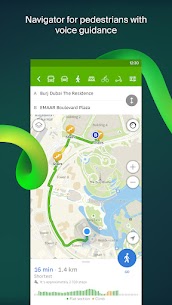
2GIS is a detailed directory with city maps and a navigator for car drivers and pedestrians. Use it online or download the city map to your device to never get lost without the internet.
With 2GIS navigation, you will feel at home even in an unfamiliar place:
— easily find the address, company, phone number, working hours, goods or services;
— find out how to get there by car, bus, metro, or follow the navigator on foot;
— find an entrance to a company, or an entrance to a building.
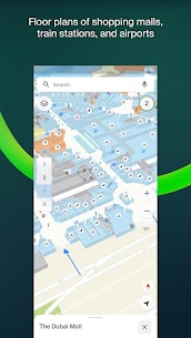
All about the buildings. 2GIS shows addresses, entrances, and postal codes.
Detailed directory. 2GIS knows phone numbers, working hours, social networks, websites, and entrance locations. Users add photos of companies and write reviews.
Accurate map. Locate districts, buildings, streets, bus stops, metro stations, gas stations, sports grounds, and other objects in 2GIS.
Navigator. Considers real-time traffic jams, road signs, traffic cameras, toll and unpaved roads, builds routes between cities and through several points. There is also a free app for Android Auto.
Road events. Reports of accidents, blocked streets, and traffic police cameras, user comments — everything is right on the map.
Public transport. 2GIS knows the timetable and online routes of public transport.
Walking routes. Pedestrian navigator paves the way wherever you can go on foot. Works in the background, supports voice guidance. Path search for pedestrians operates in 91 cities.
Travel guide. City guides: find out about the main attractions, places with Wi-Fi, and more.
Navigator for trucks. Cargo navigator gets directions for trucks considering the individual characteristics of vehicles and cargo.
A companion app for smart watches on Wear OS 3. A little something for pedestrian or public transport navigation: see manoeuvres and estimated travel time, get vibration alerts when approaching a turn or a destination bus stop. Samsung watches also support a map display. Available only for devices with Android 6 and higher.
Cities of Russia:
Moscow, Saint Petersburg, Novosibirsk, Ekaterinburg, Krasnoyarsk, Chelyabinsk, Ufa, Omsk, Kazan, Perm, Nizhny Novgorod, Sheregesh and much more.
Cities of the UAE:
Dubai, Abu Dhabi ect.
Cities of Ukraine, Belarus, Kazakhstan, Uzbekistan, Azerbaijan and Kyrgyzstan:
Dnipro, Kyiv, Kharkiv, Odessa, Minsk, Pavlodar, Semey, Aktau, Aktobe, Almaty, Nur-Sultan, Bishkek, Karaganda, Kokshetau, Kostanay, Osh, Baku, Tashkent and many more.
Support: [email protected]
What's new
Hi! Winter's coming to an end. We're sure you've been places. Now is the time to tell all about it in 2GIS to your friends and fellow users because it got easier to share photos and reviews of places. We display them the new way in the user profile and under the My 2GIS tab.
Related apps


Most rated apps
Most viewed Apps
 KartRider Rush+ 1.24.8 Apk1.24.8 NEXON Company
- BooleanTT – Boolean Algebra (PREMIUM) 2.0.7.2022 Apk2.0.7.2022 Hashan Chamara Rajapaksha
- UpdatedContacts 4.29.25.621935602 Apk4.29.25.621935602 Google LLC
- Scan Hero: Document to PDF Scanner App (PREMIUM) 1.5 Apk1.5 Apalon Apps
- UpdatedInstagram 327.2.0.50.93 Apk327.2.0.50.93 Instagram
Latest Apps
- UpdatedBeat.ly: music video maker (VIP) 2.45.10879 Apk2.45.10879 Beat.ly music video maker with effects
- mAst: Music Status Video Maker (PRO) 2.4.8 Apk2.4.8 mAst Team
- WiFi Analyzer (PRO) 5.3 Apk + Mod5.3 olgor.com
- UpdatedBitcoin Wallet Crypto Ethereum 1.29.5 Apk1.29.5 Atomic Wallet
- Workflowy |Note, List, Outline 4.0.2404301217 Apk4.0.2404301217 WorkFlowy